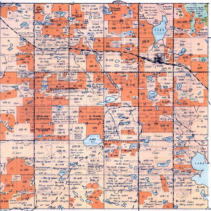

REPORT ON TOWNSHIP 50, RANGE 3, WEST OF THE FOURTH MERIDIAN
ACCESSIBILITY AND ROADS
This township is conveniently situated so far as ship- ping facilities are concerned. The village of Kitscoty is located in section 26 on the line of the Canadian National Railways between Winnipeg and Edmonton via Saskatoon and North Battleford. Good roads radiate from the village and all parts of the township are accessible.
VILLAGE
Kitscoty has a population of about 200. All lines of business essential to the needs of a farming community are represented here. The shipping facilities are good and include five elevators with a total capacity of 285,000 bushels of grain. There is a daily passenger and mail service both east and west.
SURFACE
The greater part of the northerly tier of sections and a few other odd quarter-sections are gently rolling or slightly sloping, while the remainder of the township has a rolling to heavily rolling surface, the extent of each being about evenly divided. The average elevation is about 2,175 feet above sea-level. The elevation of the lowest land is 2,025 feet and is on the west side of section 19. The highest summits have an elevation of 2,280 feet and are in the northeast quarter of section 36 and the southwest quarter of section 4.
SURFACE COVERING
Approximately one-quarter of the land is now under cultivation. The remainder is prairie and is almost entirely used for pasture.
DRAINAGE AND WATER
There are no important drainage courses. The surplus water drains to the lower areas forming many small lakes and numerous small and large sloughs, an ideal water supply for stock. Good water for domestic purposes is secured from wells, most of which range in depth from 30 to 50 feet. In the northwest comer of the township deeper drilling has been necessary as the water level is about 100 feet below the surface.
SOIL
Sections 19, 20, 21, 22, 27, 28, 29 and 30 have a predominating soil of dark clay loam. On the remainder of the township the soil is largely black fine sandy loam from 4 to 8 inches in depth over a clay or clay loam subsoil. Through out this area there are scattered patches of clay loam at clay and many stony ridges and slopes.
SETTLEMENT
The settlement of this township was begun about 190 The settlers are all English-speaking and are mostly of Canadian or American origin. About three-quarters of the lain is now occupied and a large part of it is being used as private pasture. The Provincial Government has established telephone central at Kitscoty, from which lines radiate in all directions. Nearly all the farmers have telephones.
CROPS AND STOCK
Wheat and oats are grown for grain and oat greenfeed for fodder. Barley is grown to a limited extent. All vegetables common to western Canada grow well. The settlers are engaged in mixed farming. Cattle, hogs, and horses are raised extensively. Dairying is successfully carried on and is an important source of immediate revenue.
HAY AND WINTER FEED
A limited amount of hay is secured from the slough areas which frequently dry up and from the upland prairie The most important supply of winter feed is, however, oat greenfeed and straw.
FUEL
Lignite coal is used for fuel. It is shipped in from tl Edmonton district and costs from $6 to $8 per ton at railway points.
SCHOOLS AND POST OFFICES
Good educational facilities are available at Kitscoty and a school is also located in the southwest corner of section 7. All the settlers get their mail at Kitscoty.
June, 1924.
(Sgd.)
R. H. KNIGHT,
Dominion Land Surveyor.


