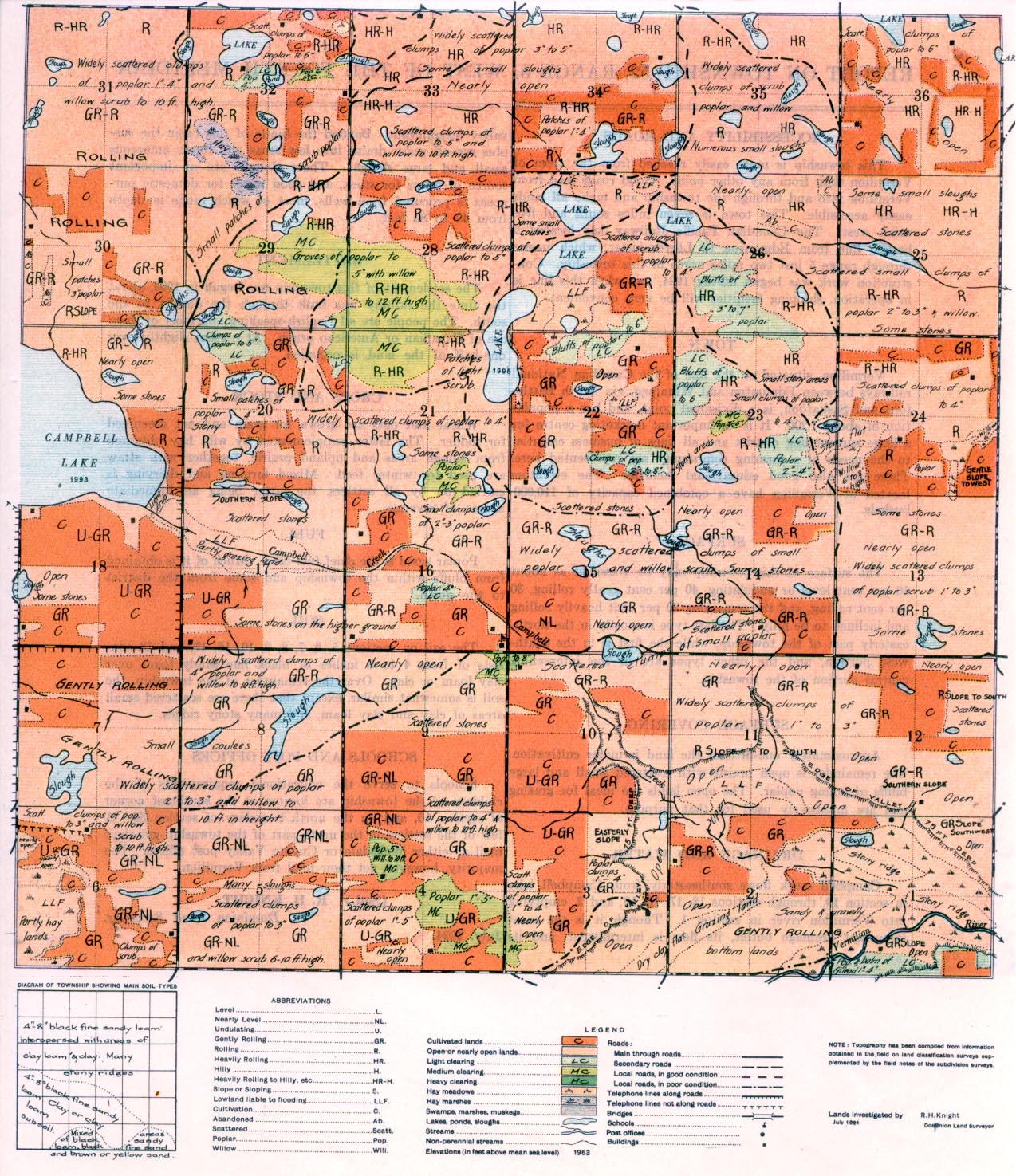
REPORT ON TOWNSHIP 52, RANGE 5, WEST OF THE FOURTH MERIDIAN
ACCESSIBILITY AND ROADS
This township is more easily reached from the town of Vermilion than from any other point. Good roads lead from Vermilion into and through the township and make all lands easily accessible. This town is seven miles south and five miles west. The Canadian Pacific Railway has located a branch line from Edmonton to Lloydminster which passes through range 5 just two miles north of this township. Construction work was begun during 1924, and when this line is in operation, shipping facilities will be very convenient.
TOWN
Vermilion, situated on the line of the Canadian National railways between Edmonton and Winnipeg, via North Battleford and Saskatoon, is a divisional point, and has a population of about 11200. It is an important marketing centre for a large surrounding district and all lines. of I business essential to the needs of a farming community are represented here. There are also good educational facilities. The elevators located at Vermilion, have a combined capacity of 110,000 bushels.
SURFACE
The surface of this township may be classified as about 10 per cent level or undulating, 40 per cent gently rolling, 30 per cent rolling, and the remaining 20 per cent heavily rolling and inclined to be hilly. The last type is mostly in the northeasterly part of the township, while the first is in the southwest portion, and the other types are in the intervening central portion of the township.
SURFACE COVERING
Approximately one-fifth of the land is under cultivation. The remainder is open prairie with scattered small and large bluffs of young poplar. The open lands are ideal for grazing and are intensively used for that purpose.
DRAINAGE AND WATER
Campbell creek flows southeasterly from Campbell lake in section 19, through sections 18, 17, 16, 10, and 2, emptying into Vermilion river in section 1. Though it is the most important drainage outlet, its flaw is intermittent, and its valley insignificant. Beyond the limits of this basin the surplus run-off water drains into low areas and forms numerous small and large sloughs. These sloughs are an important source of water for stock, and good water for domestic purposes is procured from wells, most of which range in depth from 40 to 80 feet.
SETTLEMENT
The settlement of this township was begun in 1904, about the time the railway was built through the district to the south. The people are all English-speaking and most of them are of Canadian or American origin. At present slightly over one-half of the land is occupied.
CROPS AND STOCK
Wheat and oats are grown for grain and oat greenfeed for fodder. The latter, supplemented by wild hay obtained from slough areas and upland prairie, together with straw are used for winter feed. Mixed farming and dairying is carried on by all settlers, the latter being an immediate source of revenue.
FUEL
Poplar wood is the chief fuel used. Much of it is obtained from bluffs within the township and some from the district to the north.
SOIL
The soil on sections 5, 6, 7, 8, 9, 10, 16, 17, and 18 consists of from 4 to 8 inches of black fine sandy loam over clay loam or clay. Over the remainder of the township, the soil is somewhat similar, except that there are scattered small areas of clay and clay loam, and many stony ridges.
SCHOOLS AND POST OFFICES
Schools to serve the educational requirements of the children of the township are located at the southeast comer of section 16, and on the north boundary of section 33. A few of the settlers in the north part of the township get their mail at either Wellsdale or Coyote Valley post offices. The majority, however, get their mail from Vermilion.
July, 1924.
(Sgd.)
R. H. KNIGHT,
Dominion Land Surveyor.


