REPORT ON TOWNSHIP 56, RANGE 5, WEST OF THE FOURTH MERIDIAN
ACCESSIBILITY AND ROADS
The portion of the township south of North Saskatchewan river is more easily reached from Vermilion than from any other railway point, while the part north of the river is more accessible from St. Paul des Metis. Vermilion is thirty-one miles south and five miles west, while St. Paid des Metis is twenty-one miles west and seven miles north from this township. The Canadian Pacific Railway has located a branch line between Edmonton and Lloydminster, which passed through township 53, range 5, about fifteen miles to the south. Part of this line was constructed, northwesterly from Lloydminster in 1924. When it is completed, the shipping facilities for this township will be improved.
TOWN AND VILLAGE
Vermilion, situated, on the line of the Canadian National railways between Edmonton and Winnipeg, via North Battleford and Saskatoon, is a divisional point with a population of about 1,200. It is an important marketing centre for the large surrounding district and all lines of business essential to the needs of a farming community are represented here. There aye also good educational facilities. The elevators have a combined capacity of 110,000 bushels.
St, Paul des Metis, the present terminus of a branch line of Canadian National railways from Edmonton, has a population of about 900. It is an important trading centre for a large surrounding district, and, nearly all lines of business essential to the needs of a farming community are well represented. There is a good train service to Edmonton, and excellent facilities are provided for shipping stock, grain, and dairy products.
SURFACE
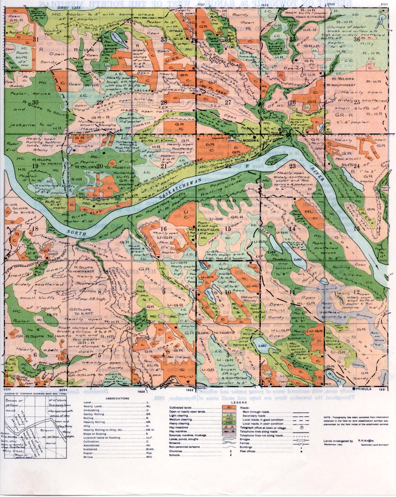
North Saskatchewan river cuts through the centre of this township, flowing easterly through sections 19, 18, 17, 16, 21, 22, 23, 24, 13 and 12. It is from 700 to 800 feet in width and has a current of approximately three miles an hour. The valley of the river averages about 20O feet in depth and is slightly over one mile wide. The elevation of the river at the middle of this township is about 1,695 feet above sea- level. The highest summit within the township and north of the river is in the northeast part and reaches an elevation of 2,100 feet. The highest summit to the south is at 2,200 feet elevation and is near the southwest corner. With an extreme difference of 500 feet in elevation on account of the river valley, this township is badly broken and fully one-half may be described as heavily rolling. The remainder of the surface is about evenly divided, between gently rolling and rolling.
SURFACE COVERING
Approximately one-twelfth of the township is now under cultivation. The greater part of the uncultivated lands are nearly open, with scattered areas of young poplar and willows. Throughout the township there are large and small areas of poplar and willow brush, with bluffs of poplar from 4 to 6 inches in diameter. The south bank of the river valley and parts of
sections 19 and 30 are covered with poplar up to 8 inches in diameter and a few scattered spruce and jack pine.
DRAINAGE AND WATER
This township is well drained by North Saskatchewan river and numerous creeks. As a consequence there are not as many sloughs and, lakes as are usually found in the district. Good water is obtained, from wells, most of which are from 30 to 70 feet deep.
SOIL
The soil of this township is very changeable although the greater part is either sandy loam or sand. The areas are so irregular that they cannot well be described, and for further information the reader is referred to the diagram of the township showing main soil types on the other sidle of this sheet.
SETTLEMENT
The settlement of this township was begun about 1906 and was encouraged by the prospect of a railway from Edmonton to North Battleford on the north side of North Saskatchewan river. At present slightly more than one-third of the land is occupied of which the greater part is being used for pasture.
CROPS AND STOCK
Wheat and, oats are the chief grain crops and oat green- feed is the main fodder crop. Nearly all the settlers are engaged in mixed, farming. Cattle and hogs are the chief kinds of stock raised.
HAY AND WINTER FEED
A limited amount of bay is secured from hay sloughs, but oat greenfeed and straw are also used for winter feed for stock.
FUEL
An abundance of poplar wood is available for fuel. When properly dried it burns well and is considered very satisfactory:
SCHOOLS AND POST OFFICES
Schools which have but one room each, are located on the east boundary of section 33 and at the southwest comer of section 2. The post offices to meet the requirements of the settlers are Primula, and Mooswa.
September, 1924.
(Sgd.) R. H. KNIGHT,
Dominion Land Surveyor.


