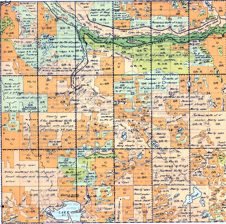
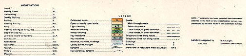
REPORT ON TOWNSHIP 51, RANGE 1, WEST OF THE FOURTH MERIDIAN
ACCESSIBILITY AND ROADS
This township is very favourably situated with reference to shipping facilities and roads. The town of Lloydminster is six miles south of the southeast corner of the township, and Bladkfoot is six miles south and one mile west of the southwest corner. From these points well-travelled roads lead into and through the township, and from them many local roads branch off making all lands easily accessible. The Canadian Pacific Railway has located a branch line from Edmonton to Lloydminster through the southwest quarter of the township. This line was graded during 1924 and when it is in operation shipping facilities will be improved.
Lloydminster, on the line of the Canadian National railways between Winnipeg and Edmonton via Saskatoon and North Battleford, is a town with a population of about 900 and is unique in that it is partly in each of the provinces of Saskatchewan and Alberta. It is an important business and
marketing centre for a district extending many miles to the north and south. All lines of business are represented here, including adequate professional services, and there are good educational institutions. The shipping facilities include five elevators with a total capacity of 140,000 bushels. There is one flour mill. On completion of the Edmonton to Lloydminster branch of the Canadian Pacific railway, Lloydminster will be an important railway point.
At Blackfoot, seven miles west of Lloyd-minster, there are two elevators, two stores, a station and a post office. People living in the west part of the township under consideration. find it a convenient shipping point.
SURFACE
Big Gully creek drains easterly through the northerly tier of sections. This creek is small and its flow is intermittent. The valley, however, is of large proportions for such a small stream. It varies from a depth of 100 feet on the north boundary of section 32 to a depth of 150 feet on the east boundary of section 35 and is slightly over half a mile in width. Back from the valley the land is slightly sloping., undulating or gently rolling. Most of the township is at an elevation ranging between 2,100 and 2,150 feet above sea level.
SURFACE COVERING
Approximately one-third of the land is under cultivation. The remainder is
prairie, with about forty percent covered with small and large bluffs of young poplar and willow. The latter is generally from six to twelve feet in height while the former ranges from two to four inches in diameter. The south bank of Big Gully valley is heavily covered with such young poplar.
DRAINAGE AND WATER
About two-thirds of the township drains northerly or easterly. In section 5 there is a lake into which water drains from a few sections. On parts of sections 1, 2, 4, 11, 14 and 15 there are numerous sloughs that have formed in the lower areas and, which have no outlet. These are an important source of water for stock. Good water for domestic purposes is somewhat difficult to obtain and many wells are from 100 to 150 feet deep.
SOIL
Parts of sections 5, 6, 7, 8, 10, 11 and 12 have areas of black sandy loam. Otherwise the principal soil type of the township is black fine sandy loam interspersed with areas of black loam. These soils are from six to twelve inches deep and have a subsoil of clay loam or clay.
FUEL
Wood for fuel is obtained from the many bluffs of poplar. A few farmers use lignite coal which is shipped in from the Edmonton district and costs from $6 to $8 per ton at railway
SEITIBMENT
Settlement in this locality was begun in 1903, just previous to the construction of the railway through the district to the 5outh. At present seventy-Eve per cent of the land is occupied the greater part of which is used as private pasture. The settlers are all English-speaking and of Canadian, English or American origin.
CROPS AND STOCK
Wheat and oats are grown for grain and oat greenfeed for fodder. Barley is grown to a limited extent and is used chiefly as feed. Wild hay is secured from some of the slough areas that frequently dry up while upland hay is cut from the prairie. Hay is supplemented by oat greenfeed and, straw, which together constitute the winter feed for stock. Mixed farming is carried on by most of the settlers. Cattle, hogs and horses are raised. Dairying is successfully engaged in and is found to be an important source of revenue.
POST OFFICES AND SCHOOLS
The most convenient post offices are Staplehurst, Streamstown, and Lloydminster. The last point has a daily mail service to and from both east and west. Schools are located at the northeast corner of section 9, on the west boundary of section 31 of the township to the south and on the north boundary of section 23 of the township to the west.
(Sgd.) R. H. KNIGHT,
Dominion Land Surveyor,
June, 1924.


