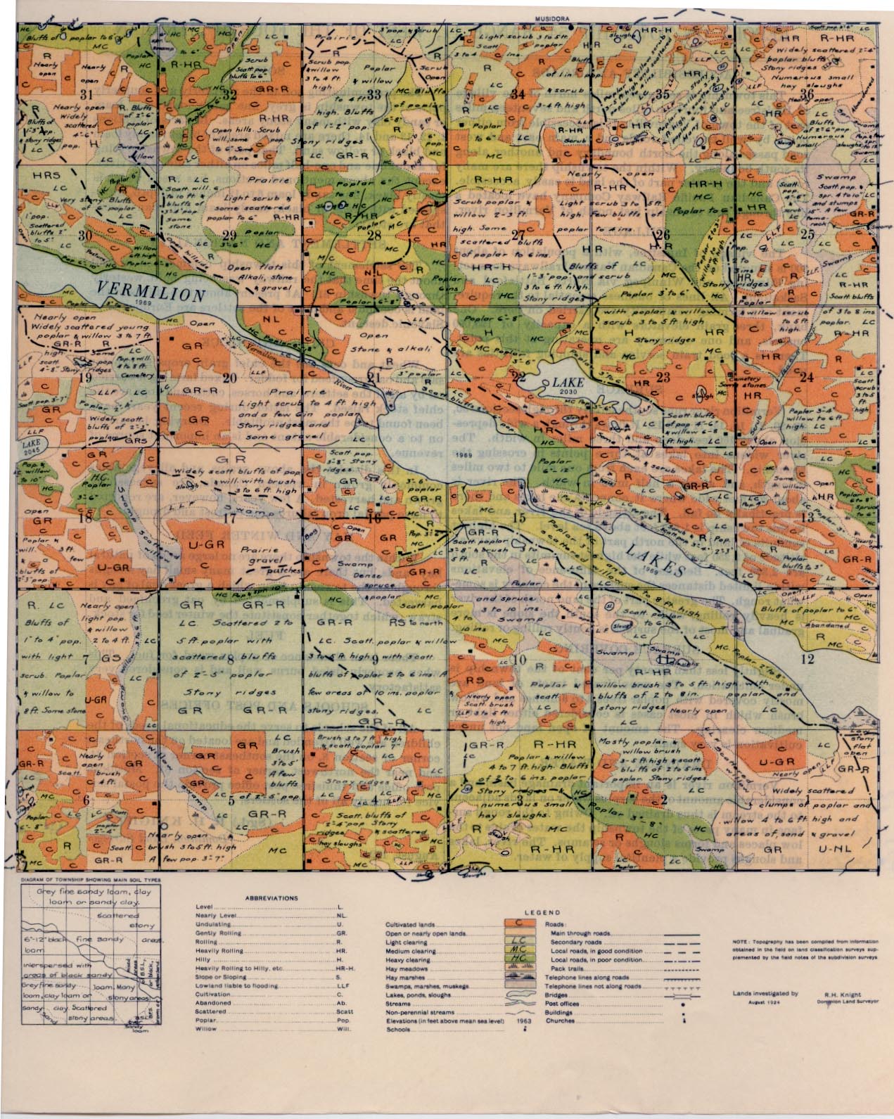
REPORT ON TOWNSHIP 54, RANGE 11, WEST OF THE FOURTH MERIDIAN
ACCESSIBILITY AND ROADS
This township is seventeen miles north of the village of Innisfree and fourteen miles north and seventeen miles east of the town of Vegreville. It is accessible from either point by well-travelled roads and a main east and west road passes along the north boundary and another along its south boundary. Within the township there are many roads and the greater part of the land is easily accessible. The Canadian Pacific Railway Company have located a line through this township just north of Vermilion river.
VILLAGE
The village of Innisfree, with a population of about 300 is situated on the Canadian National railways connecting Edmonton and Winnipeg via North Battleford and Saskatoon. All lines of business essential to the requirement of a farming community are carried on here. One bank, three grain elevators with a capacity of 125,000 bushels, and one creamery are operating at this point. There is a good train service and shipping facilities are good.
SURFACE
Vermilion river runs southeasterly through sections 30, 29, 20, 21, 15, 14, 11 and 12. It flows through a wide depression about 150 feet deep and three miles in width. The river widens into lakes at three points in crossing the township. The lakes are each from one mile to two miles in length, and about a half mile in width. The river is about 300 feet wide where it connects the lakes and there is practically no fall. The altitude of the river and lakes in this township is 1,969 feet above sea level. The highest summits of land in the north part of the township have an altitude of 2,250 feet while the highest summits in the south are 2,300 feet. Because of the difference of elevations within limited distances the surface of the country is some- what rough. The greater part of the land north of the river is heavily rolling, while to the south the slope is more gradual and most of the surface is gently rolling or rolling.
SURFACE COVERING
Slightly less than twenty per cent of the township is under cultivation. The uncultivated tracts of land are mostly covered with poplar trees 3 to 6 inches and willow brush which in most cases is considered either light or medium clearing. The amount of open land not under cultivation is very small.
DRAINAGE AND WATER
Vermilion river is an important drainage basin and a considerable amount of the surplus water on lands adjacent to the stream is thus drained off. Owing to the rough surface in many parts of the township the water drains to the low places and forms sloughs or swamps. The river, lakes and sloughs provide a plentiful supply of water.
SOIL
The predominating soil in the northerly and southerly parts of the township is grey, fine sandy loam, clay loam or sandy clay with many stony areas. In parts of sections 1, 12, 13 and 14, there are mixed areas of black, sandy loam and black or yellow sand. That part of the township lying for about one and one-half miles on either side of the river, except the above mentioned sections, has a soil which is mostly black, fine sandy loam 6 to 12 inches in depth,
interspersed with areas of black, sandy loam and many areas that are stony.
SETTLEMENT AND NATIONALITY
The settlement of this township commenced in 1904 about the time that the railway was being built westerly through township 51. At present about two-thirds of the land is occupied and most of the settlers are Europeans of Slavonic descent.
CROPS AND STOCK,
Wheat and oats are the chief grain crops grown for sale and oat greenfeed for fodder. Mixed farming is carried on by all of the settlers, and horses, cattle and hogs are the chief stock raised. The latter during recent years have been found to be the most profitable. Dairying is carried on to a considerable extent and is an important source of revenue.
In this district the above grains, and all vegetables commonly grown in western Canada, are successfully grown and harvested. A few years, however, are reported to have partial crop failures due to frost and drought.
HAY AND WINTER FEED
Within the township there are no large areas of natural hay lands, but there are a great many small hay sloughs throughout the township from which a great deal of hay is harvested. This is supplemented by oat greenfeed and straw, which together constitute the winter feed for stock.
FUEL
There is an abundance of poplar wood for fuel. This when properly dried burns well and is considered very satisfactory.
SCHOOLS AND POST OFFICES
All of the schools to serve the educational needs of the children are well attended and are located on the northeast corner of section 8, on the southeast corner of section 34, and near the northwest corner of section 31. Musidora post office and Innisfree post office provide the postal service for nearly all of the settlers.
(Sgd.) R. H. KNIGHT, Dominion Land Surveyor
August, 1924


