REPORT ON TOWNSHIP 53, RANGE 3, WEST OF THE FOURTH MERIDIAN
ACCESSIBILITY AND ROADS
This township is reached either from Kitscoty fourteen miles to the south or from Islay which is ten miles south and four miles west. Both these points are on the line of the Canadian National Railways between Winnipeg and Edmonton via Saskatoon and North Battleford. A main road from Kitscoty runs north through the township one mile west of the east boundary and a main road from Islay runs north one mile west of the township. From these main roads many local roads branching off make nearly all parts of the township accessible.
VILLAGES
The village of Kitscoty has a population of about 200. All lines of business essential to the needs of a farming community are represented here. The shipping facilities are good and include five elevators with a total capacity of 285,000 bushels of grain. There is a daily passenger and mail service both east and west.
The village of, Islay, in the southerly part of township 51, range 4, is an important trading centre for a large district to the north and south. Nearly all lines of business essential to the needs of the farmer are also represented here. There are good shipping facilities, including four elevators with a total capacity of 175,000 bushels.
SURFACE
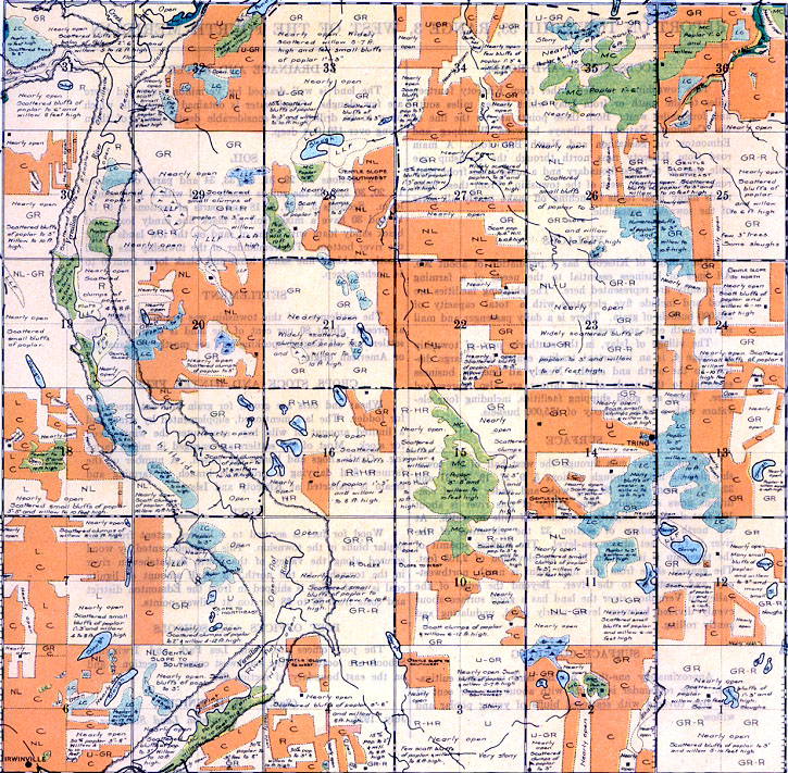
Vermilion river cuts through the west half of the town- ship flowing north through sections 5, 9, 17, 19, 30, 31 and 32. It is from 60 to 80 feet wide and under normal conditions flows sluggishly. The valley of this river is about 100 feet deep and slightly over one-half mile in width. At the north boundary of section 32 the elevation of the river is 1,765 feet above sea-level. The highest summit of the township is in section 14 at an elevation of 2,165 feet. The general slope from this high point is north, northwesterly and westerly to the river. Beyond the edge of the valley of Vermilion river the land has a good surface about evenly divided between level, nearly level, undulating and gently rolling.
SURFACE COVERING
Approximately one-third of the land is under cultivation. The remainder is prairie with about ten per cent of the area covered with scattered bluffs of young poplar and willow.
DRAINAGE AND WATER
The land is well drained by Vermilion river and there are few sloughs. Good water is obtained from wells which have to be drilled to a considerable depth, many of them being over 150 feet deep.
SOIL
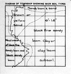
On sections 28, 29, 31, 32, 33, 34 and parts of sections 19, 20, 30 and 35 the soil is mostly sand with a little sandy loam. Sections 5, 6, 7, 8, 18 and parts of sections 4, 9, 17, 19 and 30 have a mixed soil of black fine sandy loam and black sandy loam with areas of sand on the low lands along the river bottom. The remainder of the township has a soil mostly of black fine sandy loam and black loam from 6 to 14 inches deep.
SETTLEMENT
The settlement of this township was begun in 1905 and at present about 80 per cent of the land is occupied. The settlers are all English-speaking and are mostly of Canadian or American origin.
CROPS, STOCK AND WINTER FEED
Wheat and oats are grown for grain and oat greenfeed for fodder. The last mentioned, supplemented by straw and a limited amount of wild hay, constitutes the winter feed for stock. Most of the settlers are engaged in mixed farming. Cattle, hogs and horses are raised. A number of the farmers find dairying a profitable branch of farming and cream is marketed at Kitscoty and Islay.
FUEL
Wood for fuel is secured to a limited extent from the poplar bluffs in the township. This is supplemented by wood secured along the valley of the North Saskatchewan river in the township to the north. A small amount of lignite coal is used which is shipped in from the Edmonton district and costs from $6 to $8 per ton at railway points.
POST OFFICES AND SCHOOLS
The post offices are Tring, Lea Park and Irwinville. Schools are located in the southwest corner of section 2 and on the east boundary of section 28.
July, 1924.
(Sgd.)
R. 11. KNIGHT,
Dominion Land Surveyor.


