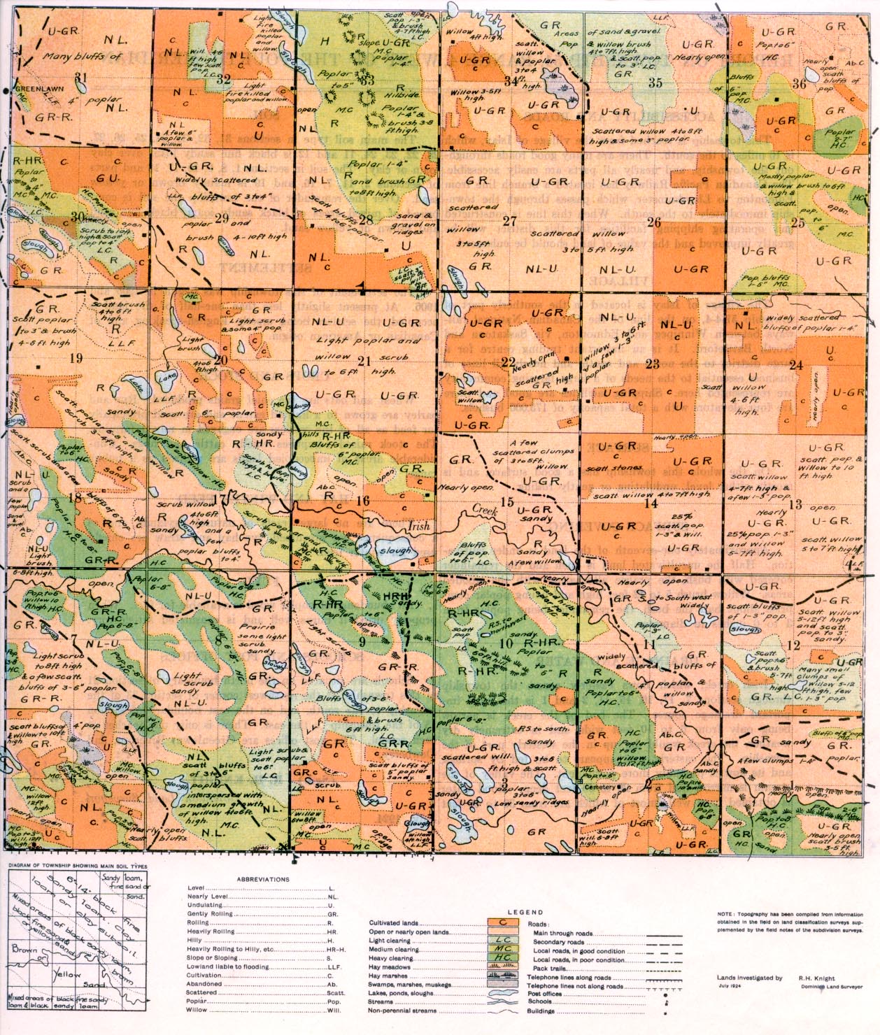
REPORT ON TOWNSHIP 54, RANGE 4, WEST OF THE FOURTH MERIDIAN
ACCESSIBILITY AND ROADS
This township is reached from the village of Islay, which is 16 miles to the south. There are many good roads through out the township, and nearly all parts are easily accessible. The Canadian Pacific Railway has located a branch line from Edmonton to Lloydminster, which passes through the township immediately to the south. When this line is constructed and operating shipping facilities for this district will be greatly improved and the value of land should be enhanced.
VILLAGE
The village of Islay is located, in the southerly part of township 51-4-4, on the line of the Canadian National rail- ways between Winnipeg and Edmonton, via Saskatoon and North Battleford. It is an important trading centre fora large district to the north and south, and nearly all lines of business essential to the needs of a large farming community are represented here. Shipping facilities are good and there are four elevators with a total capacity of 175,000 bushels.
SURFACE
On the whole this township has a good surface, and mostly either level, undulating or gently rolling.
SURFACE COVERING
Approximately one-seventh of the land is under cultivation. Half the uncultivated land is open and the remainder covered with bush, the prairie alternating with the wooded areas. Willow brush 5 to 1,2 feet high and young poplar comprise about half the bush, the remainder being poplar from 3 to 6 inches in diameter.
DRAINAGE AND WATER
Irish creek, which flows easterly across the township through sections 7, 17, 16. 15, 11, 2 and I is the most important drainage course. The bed of the creek is narrow being only from 6 to 10 feet wide and in extremely dry weather, the creek would dry up in the westerly part of the township. The easterly part appears to be fed by springs, and its flow is probably more permanent. The valley of the stream is narrow and from 20 to 50 feet deep. Good water is obtained from wells most of which are from 30 to 60 feet deep.
SOIL
The main soil type in sections 31, 32, 33, 34, 25, 26, 27, 28, 22, 23, 24, 11 and 12 is black fine sandy loam over clay loam or clay. The soil in sections 1, 8, 9, 10, 17, 18 and parts of sections 2, 11, 7, 16, and 19 is mainly brown or yellow sand. Over the remainder 6f the township the soil is comprised of mixed areas of black sandy loam, black fine sand and brown or yellow sand.
HAY AND WINTER FEED
There are no large tracts of natural haylands, and as a consequence oat greenfeed, rye hay and straw are chiefly used for winter feed.
FUEL
An abundance of poplar wood is available for fuel. When properly dried it burns well and is considered satisfactory.
SETTLEMENT
The settlement of this township was begun in 1905 and 1906. At present slightly less than one-half of the land is occupied, the
settlers being mostly English-speaking and of Canadian or American origin.
CROPS AND STOCK
Wheat and oats are the chief grains produced. Rye and barley are grown to a limited extent and are used principally for feed as all of the settlers are engaged in mixed farming. The stock raised comprises chiefly cattle and hogs. Considerable areas of unoccupied lands are utilized as a public range.
SCHOOLS AND POST OFFICES
Schools are situated an the north boundary of section 21 of this township, at the northwest corner of section 33 of the township to the south, and on the east boundary of section 18 of the township to the east. There is only one teacher at each school. The post offices are Greenlawn, Riverton, and Dewberry.
(Sgd.) R. H. KNIGHT,
Dominion Land Surveyor.
July, 1924. 1


