REPORT ON TOWNSHIP 52, RANGE 2, WEST OF THE FOURTH -MERIDIAN
ACCESSIBILITY AND ROADS
This township can be reached from either Kitscoty, one mile west and eight miles south, Blackfoot, eleven miles south, or Lloydminster, twelve miles south and six miles east. Well travelled roads lead into the township from all of the above places and many local roads branching off make all lands accessible.
The Canadian Pacific Railway has located a branch line from Edmonton to Lloydminster which passes through the southwest quarter of this township. Twenty miles of this a railway was graded northwesterly from Lloydminster in 1924. When it is operating, shipping facilities will be very convenient.
VILLAGES
The village of Kitscoty, situated on the line of the Canadian National railways between Winnipeg and Edmonton via Saskatoon and North Battleford, has a population of about 200. All lines of business essential to the needs of a farming community are represented here. The shipping facilities are good and there are five elevators with a total capacity of 285,000 bushels of grain. There is a daily passenger and mail service to both east and west.
Though Blackfoot is not even a village it is a very convenient shipping point for an extensive district to the north and a limited district to the south. It is about eight miles southeast of Kitscoty and on the same line of the Canadian National railways. There are two grain elevators with a total capacity of 70,000 bushels, a station, a post office, two general stores and a small hotel at this point.
SURFACE
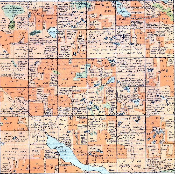
The surface of this township on the whole is good. The land, of the southwesterly half is classified as nearly level, slightly sloping, undulating or gently rolling. The northeasterly half of the township is very largely undulating and gently rolling, with some areas that are rolling, and a few quarter sections that are heavily rolling. Most of the land in this township is at an elevation ranging from 2,000 to 2,100 feet above sea-level.
SURFACE COVERING
Approximately one-third of the land is now under cultivation. The remainder is prairie, with generally from ten to twenty per cent covered, with mixed bush of young poplar and willow. The poplar is from one to three inches in diameter and the willow from five to twelve feet high. I
DRAINAGE AND WATER
The most important drainage is through St. Ives lake, in sections 3, 4, 5, and 8, and its outlet Marwayne creek which flows northwesterly through sections 8 and 18. Slightly more than the southwesterly half of the township drains this way, while the northeasterly part drains north. A few scattered sections are only partially drained, the surplus water gathering on the lower lands, where large and small sloughs are formed.
SOIL
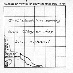
Parts of sections 5, 6, 7 and 8 have a light sandy soil, otherwise the principal type of soil throughout the township is black fine sandy loam, to depths ranging from six to ten inches, over a clay or clay loam subsoil.
FUEL
Wood is used for fuel and a limited amount is obtained within the township but, since the trees are small and scarce, considerable quantities are hauled in from points farther north.
SETTLEMENT
Settlement was begun in this township in 1903, just prior to the construction of the railway through the district to the south. At present seventy per cent of the land, is occupied and the land which is not under cultivation is being used as private pasture.
The settlers are all English-speaking and are mostly of Canadian, English or American origin.
CROPS, STOCK AND WINTER FEED
Wheat and oats are the principal grains grown, wheat covering the greater acreage. Barley is grown to a limited extent and is mostly used as feed. Oat greenfeed is the principal fodder crop and is, supplemented by the large quantities of available straw and a limited amount of wild hay which is cut from upland prairie and slough areas. These together constitute the winter feed for stock. Mixed farming is carried on by most of the settlers. Cattle, hogs and a few horses are raised. Dairying is engaged in to a limited extent.
POST OFFICES AND SCHOOLS
Adequate postal facilities are provided by Strearnstown, Willowlea, Bellcamp and Marwayne post offices. Schools are located at the southeast corner of section 13, the southwest corner of section 16, and near the northwest corner of section 33.
June, 1924.
(Sgd.)
R. H. KNIGHT,
Dominion Land Surveyor.


