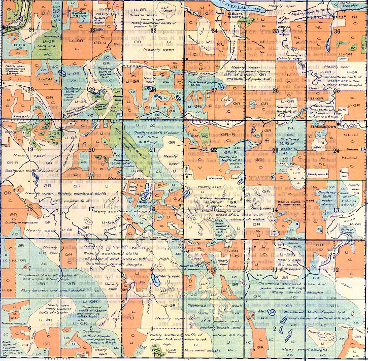
REPORT ON TOWNSHIP 51, RANGE 2, WEST OF THE FOURTH MERIDIAN
ACCESSIBILITY AND ROADS
This township is favourably situated in that the village of Kitscoty is only 1 mile west and 2 miles south of the southwest corner. Blackfoot is five miles south and Lloydminster is 6 miles east and 6 miles south of the township, These three points are located on the line of the Canadian National Railways between Winnipeg and Edmonton via Saskatoon and North Battleford. Main roads from them run into and through the township and from these many local roads branch off and make all lands easily accessible. The Canadian Pacific Railway has located a branch line between Lloydminster and Edmonton which passes through the northeast quarter of the township.
VILLAGE
The village of Kitscoty has a population of about 200. All lines of business essential to the needs of a fanning community are represented here. The shipping facilities are good and include five elevators with a total capacity of 285,000 bushels of grain. There is a daily passenger and mail service both cast and west.
SURFACE
The surface of this township is slightly sloping, undulating and gently rolling. The northeasterly half has a very gentle slope to the north. Most of the land has an elevation ranging from 2,050 to 2,150 feet above sea-level. The highest Summit in the southwest comer of the township has an elevation of slightly less than 2,300 feet above sea-level.
SURFACE COVERING
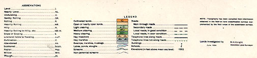
Approximately one-third of the land is under cultivation. The remainder is prairie with about 25 per cent of the surface covered with small and large bluffs of mixed young poplar and willow. The willow ranges in height from 6 to 12feet and the poplar is from 1 to 4 inches in diameter.
DRAINAGE AND WATER
On account of the gently sloping surface this township is well drained. There are two main drainage courses, one running northerly through the east part of the township and the other northwesterly through sections 4, 9, 8, 17, 18 and 19. On a few areas of land the surplus water cannot reach these drainage courses and collects in the lower places forming sloughs. These are mostly on parts of sections 1, 2, 3, 9, 10, 14 and 15. Water is obtained from wells, most of which are 100 feet or more in depth.
SOIL
The main soil types of this township are black loam and black fine sandy loam. They are from 6 to 12 inches in depth over a clay loam or clay subsoil. All soils have a high proportion of silt.
SETTLEMENT
The settlement of this township was begun in 1903 just prior to the construction of the railway through the district to the south. At present seventy-five per cent of the lands are occupied. The settlers are all English-speaking and are mostly of Canadian, English and American origin.
CROPS, STOCK AND WINTER FEED
Wheat and oats are grown for grain and oat greenfeed for fodder. Barley is grown to a limited extent and is largely used for feed. Hay is cut on some of the slough areas which frequently dry up and on the upland prairie. Hay, oat greenfeed, and straw together constitute the winter feed for stock. Mixed farming is carried on by most of the settlers. Cattle and hogs are the chief kinds of stock raised. Dairying is successfully engaged in and is found to be an important source of revenue.
FUEL
Poplar wood for fuel is obtained from the bluffs. A few farmers use lignite coal which is shipped in from Edmonton district and costs from $6 to $8 per ton at railway points.
SCHOOLS AND POST OFFICES
The schools are substantially built and in common with others in the country have but one room each. They are situated at the southwest comer of section 29, on the north boundary of section 23 on the south boundary of section 4, and on the east boundary of section 36, township 50, range 2. The post offices are Kitscoty, Streamstown, and Staplehunt.
(Sgd.)
R. H. KNIGHT,
Dominion Land Surveyor.


