This group of photos goes from Lac St Cyr in the West to NE of Laurier Lake in the East and includes Stoney Lake, Elk Point, Lindbergh and Laurier Lake. Check out the Table below or use the menu of the side to access the photos.
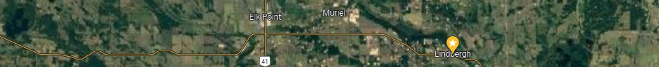
The map below is the approximate coverage of this line of Arial photos.
| Line 5 Photo 133 Lac St Cyr |
| Line 5 Photo 134 NW Stony Lake |
| Line 5 Photo 135 Stony Lake North |
| Line 5 Photo 136 NE Stoney Lake |
| Line 5 Photo 137 East of Armistice Lake |
| Line 5 Photo 138 Armistice Lake |
| Line 5 Photo 139 West of Elk Point |
| Line 5 Photo 140 Elk Point |
| Line 5 Photo 141 East of Elk Point |
| Line 5 Photo 142 Muriel Siding |
| Line 5 Photo 143 CN Gravel Pitt |
| Line 5 Photo 144 E of Simmo Lake |
| Line 5 Photo 145 Simmo Lake |
| Line 5 Photo 146 Mooswa Creek |
| Line 5 Photo 147 Lindbergh & Riverview |
| Line 5 Photo 148 E of Lindbergh |
| Line 5 Photo 149 N of Laurier Lake |
| Line 5 Photo 150 |
| Line 5 Photo 151 NW of Laurier Lake |
| Line 5 Photo 152 N of Laurier Lake |
| Line 5 Photo 153 NE of Laurier Lake |


