REPORT ON TOWNSHIP 54, RANGE 2, WEST OF THE FOURTH MERIDIAN
ACCESSIBILITY AND ROADS
This township is reached from the village of Kitscoty, which is twenty miles south and one mile west. A main market road to this village passes one mile west of this township and a local road branching off enters the township along the north boundaries of sections 7 and 8. There is also al main travelled road along the north boundary of the town ship from which local roads branch off. About one-half of the land is now reached by established roads and trails.
VILLAGE
The village of Kitscoty, situated on the line of the Canadian National railways between Winnipeg and Edmonton, via Skskatoon and North Battleford, has a population of about 200. All lines of business essential to the needs of a farming community are represented here. The shipping facilities are good and there are five elevators with a total capacity of 285,000 bushels of grain. There is a daily passenger and mail service to both east and west.
SURFACE
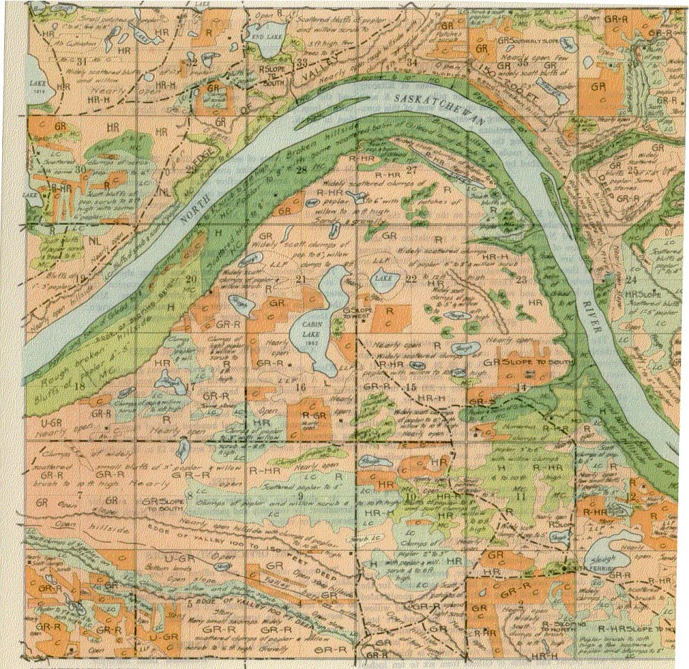
The North Saskatchewan river flows easterly across the northerly half of this township, making a wide detour through sections 18, 19, 20, 29, 28,33, 34, 35, 26, 23, 24, 13 and 12. It is from 1,000 to 1,200 feet wide and has a current of approximately three miles per hour. The valley is 200 feet deep and about one mile wide. The elevation of the river, where it leaves the township, is about 1,650 feet above sea-level, while the general elevation of the land back from the river valley is from 1,900 to 2,000 feet above sea-level. The surface of the portion of the east half of the township south of the river is mostly rolling to heavily rolling, and in places inclined to be. hilly. The Surface of the portion of, the west half south of the river is about evenly divided between gently rolling and rolling, with a few quarter-sections of heavily rolling land. North of the river the west half is rolling and heavily rolling, while the cast half is mostly gently rolling.
SURFACE COVERING,
Approximately one-tenth of the land in this township is under cultivation. The rough surface, presence of the river and long distance from market is largely accountable for the small proportion of land being cultivated. The uncultivated land is prairie with numerous bluffs of poplar and willow. These bluffs covering about one-third of the land are both small and large and consist of small poplar and willow withmany scattered areas of poplar from four to six inches in diameter. The south side of the river valley is thickly covered with poplar and balm of Gilead from six to ten inches in diameter.
DRAINAGE AND WATER
The land of this township is well drained by the river and the many tributary water courses. Good water is obtained from wells most of which are from thirty to eighty feet in depth.
SOIL
The greater parts of sections 21, 22, 27, 28, 29, 31, 32, 33, 34 and 35 have alternating areas of black sandy loam, black fine sand and brown or yellow sand. On the remainder of the township the main soil type is black fine sandy loam from four to eight inches in depth and is interspersed with scattered small areas of clay loam, clay and many stony knolls and ridges.
SETTLEMENT
The settlement of this township was begun about 1908 and at present About one-half of the land is occupied, the greater part of which is being used as private pasture. Most of the settlers north of the river are of Scandinavian origin, while those south of the river are English-speaking.
CROPS, STOCK AND WINTER FEED
Wheat and oats are grown for grain and oat greenfeed for fodder. A limited amount of wild hay is cut from the slough areas and uplands. This hay, with greenfeed and straw, is used for winter feed for stock. All of the settlers are engaged in mixed farming. Cattle, hogs and horses are raised. A large cattle ranch, with several hundred head of stock, is being operated in the triangular tract of land formed by the river and the north boundaries of sections 13 to 18 inclusive.
FUEL
An abundance of poplar wood for fuel is available throughout the township and particularly in the North Saskatchewan river valley.
CROPS, STOCK AND WINTER FEED
Wheat and oats are grown for grain and oat greenfeed for fodder. A limited amount of wild hay is cut from the slough areas and uplands. This hay, with greenfeed and straw, is used for winter feed for stock. All of the settlers are engaged in mixed farming. Cattle, hogs and horses are raised. A large cattle ranch, with -several hundred head of stock, is being operated in the triangular tract of land formed by the river and the north boundaries of sections 13 to 18 inclusive.
POST OFFICES AND SCHOOLS
The most convenient post offices are Lea Park, Onion Lake, and South Ferrilby. Schools are located at the southwest comer of section 14, at the northeast comer of section 26 of the township to the west, and near the northwest comer of section 20 of the township to the east.
(Sgd.) R. H. KNIGHT,
Dominion Land Surveyor.
July, 1924.


