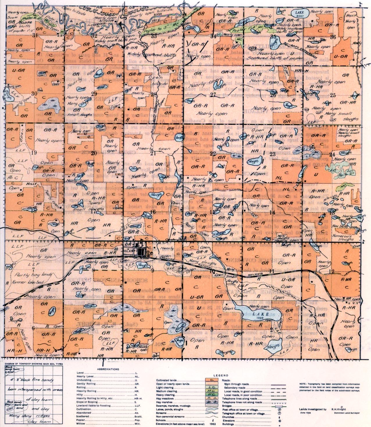
REPORT ON TOWNSHIP 51, RANGE 4, WEST OF THE FOURTH MERIDIAN
ACCESSIBILITY AND ROADS
This township is favourably situated, in that the Canadian National railway crosses the southerly part of the township and the village of Islay is situated on section 9. The Interprovincial highway between Edmonton and Saskatoon is located along the north boundaries of sections 7 to 12 inclusive. From Islay main roads lead into the country for many miles to the north and these with the local roads branching off through the township make all parts accessible.
VILLAGE
The village of Islay is on the line of the Canadian National railways between Winnipeg and Edmonton, via Saskatoon and North Battleford. It is an important trading centre for a large district to the north and south and nearly all lines of business essential to the needs of a large farming community are represented here. The shipping facilities are good and there are four elevators with a total capacity of 175,000 bushels.
SURFACE
Vermilion river cuts through the northerly part of this township flowing easterly through sections 31, 32 and 33. This stream is about 50 feet wide and under normal conditions its flow is sluggish. The river valley is slightly over 100 feet in depth and is about three-quarters of a mile wide, At the north boundary of section 33 the elevation of Vermilion river is approximately 1,870 feet above sea-level while the mean elevation of the surface of the township, is about 2,000 to 2,050 feet. Away from the river valley the surface alternates between gently rolling, rolling, and heavily rolling, these classes being in about equal proportions.
SURFACE COVERING
Approximately one-third of the land is under cultivation. The remainder is prairie and is being intensively pastured.
DRAINAGE AND WATER
The principal drainage in this township is through a small creek, flowing northerly through sections 16, 21, 28 and 33 to the Vermilion river, and a number of small tributaries in the south part of the township. The areas drained by these creeks axe narrow and the surplus water of the remainder of the township collects on the lower lands forming a considerable number of sloughs. Good water is obtained from wells, most of which are from 40
to 60 feet deep.
SOIL
Most of sections 7, 8, and 31 and parts of sections 9, 17, 18, and 32 have a soil that is mostly black sand loam. On the remainder of the township the soil is very largely black fine sandy loam to depths of from 4 to 8 inches, interspersed with small areas of clay loam and clay, and with many stony ridges and slopes.
SETTLEMENT
The settlement of this township was begun in 1904, the year that the railway was being constructed through this district. At present about 85 per cent of this land is occupied. All of the settlers are English-speaking and most of them are of Canadian or American origin.
CROPS AND STOCK
Wheat and oats are grown for grain and oat greenfeed for fodder. Rye and barley. are grown to a limited extent. Considerable wild hay is cut along the flats near Vermilion river and a limited amount is secured from slough areas and upland prairie. Hay is supplemented with oat greenfeed and straw, for winter feed for stock. Mixed farming is carried an by many settlers. Horses, cattle and hogs are the chief kinds of stock raised. 'Dairying is successfully engaged in and is found to be an important source of revenue.
FUEL
A limited amount of wood is used for fuel and is hauled in from points farther north. Lignite coal, however, is the fuel most used. It is shipped in from the Edmonton district and costs from $6 to $8 per ton at Islay and other railway points.
SCHOOLS AND POST OFFICES
Good educational facilities are available at Islay and there are also schools near the northeast comers of sections 12 and 36. All of the farmers get their mail at Islay. There is a daily mail service to and from both east and west.
(Sgd.) R. H. KNIGHT,
Dominion Lands Surveyor.
June, 1924.


