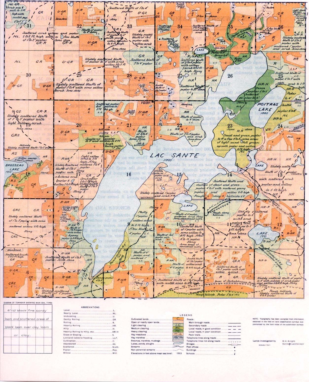
REPORT ON TOWNSHIP 56, RANGE 11, WEST OF THE FOURTH MERIDIAN
ACCESSIBILITY AND ROADS
This township is easily reached from St. Paul des Metis, which is eight miles east and seven miles north. The main ( through road connecting the above place with Vegreville I passes through the northwesterly part of the township. Within I the township there are many good, roadis and nearly every part is easily accessible.
VILLAGE
St. Paul des Metis, the present terminus of a branch line of the Canadian National railways from Edmonton has a population of about 900. It is an important trading centre for a large surrounding district and nearly all lines of business essential to the needs of a farming community are well represented. There is a good train service to Edmonton,: and excellent facilities are provided for shipping stock, grain, and dairy products.
SURFACE
Lao Sante, at an elevation of 1,990 feet above sea-level, is over six miles long and from one quarter to one mile in width. It lies in a northeasterly and southwesterly direction entirely within this township and has an area of about 2,200 acres. This lake has an outlet draining through sections 14, 13, 12, and 1, into North Saskatchewan river. The surface of the land lying northwest of the lake is gently rolling with a gradual slope towards the lake. The highest summit in this part of the township is slightly over 100 feet above the lake. In the southeasterly part of the township the land is mostly heavily rolling and inclined to be rough.
SURFACE COVERING
Approximately one-quarter of the land in this is under cultivation, most of which is northwest te. The uncultivated areas are largely open wit
SURFACE COVERING
Approximately one-quarter of the land in this township is under cultivation, most of which is northwest of lac Sante. The uncultivated areas are laxgely open with scattered bluffs of poplar and willow from 2 to 4 inches in diameter. A few areas of limited extent have a somewhat thicker growth of bush but are considered as light clearing.
DRAINAGE AND WATER
Most of the township drains into lac Sante and it provides an important source of water for stock. Good water is obtained from wells twenty to seventy feet in depth.
SOIL
The predominating soil is black fine sandy loam to a depth of from six to ten inches, with scattered areas of black loam. The subsoil is mostly either clay loam or clay. East of the lake there are several stony areas.
SETTLEMENT
The settlement of this township was begun in 1905. Most of the settlers in the northwesterly half of the township are French
Canadians, while the majority in the southeasterly part are Europeans of Slavonic descent.
CROPS AND STOCK Wheat and oats are the ;chief grain crops, while oat greenfeed is the main fodder crop. Mixed farming is carried on by nearly all of the settlers. Horses, cattle and hogs are the chief kinds of stock raised. During recent years hogs have been found to be the most profitable. Dairying is car- ried on to a limited extent, cream being sold at St. Paul
HAY AND WINTER FEED
There are no large tracts of natural haylands, but a limited amount of hay is cut from a few places around Lac Sante and from the small hay sloughs found within the township. Hay is supplemented by oat greenfeed and straw for winter feed for stock.
FUEL
There is an abundance of poplar wood for fuel. When properly dried it burns well and is considered satisfactory.
SCHOOLS AND POST OFFICES Schools attended by the children of this township are located as follows: at the northwest corner of section 27 and near the southwest comer of section 4 of this township; on the northwest quarter of section 25 of township 56-12-4; on the southeast corner of section 18 of township 56-10-4; and on the southwest comer of section 5 of township 57-10-4. Adequate postal facilities axe provided by Foisy post office at the northeast corner of section 21, Lafond post office one mile east of the northeast corner of the township, and by Brosseau post office in section 35 of township 55-12-4.
(Sgd.) R. H. KNIGHT,
Dominion, Land Surveyor. October, 1924.


