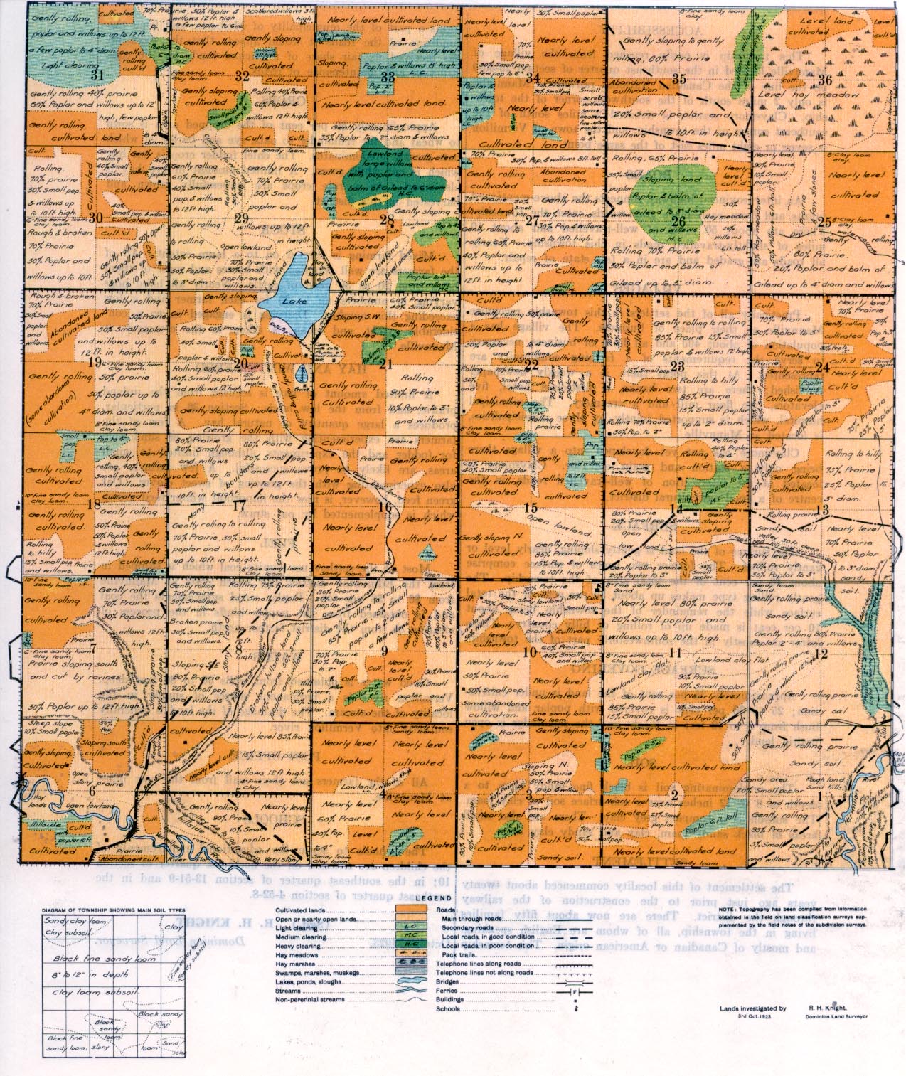
REPORT ON TOWNSHIP 51, RANGE 8, WEST OF THE FOURTH MERIDIAN
ACCESSIBILITY
This township is easily reached from the village of Mannville located in the southeast quarter of section 25-50-9 on the line of the Canadian National railways. Mannville is only 2 miles south of the southwest corner of the township. Claysmore station is situated 2 miles south of the southeast corner of the township, and the town of Vermilion seven or eight miles east of the same point.
. An interprovincial highway connects the above-mentioned points and from each place good roads enter the township. There are about 50 miles of well-travelled and about 10 miles of slightly-travelled, roads in this township. Nearly all roads are graded and are in a fair state of repair.
There are about 50 miles of well-travelled and about 10 miles of slightly-travelled, roads in this township. Nearly all roads are graded and are in a fair state of repair.
VILLAGES
Practically all of the settlers in this township recognize Mannville as their place of business. The village has a population of about 400 and all lines of business, necessary to serve the requirements of a farming community are represented. At this point there is a weekly newspaper published; there axe two banks, a first-class hotel, five elevators, one flour mill and a creamery. The municipal hospital, which is supported jointly by three municipalities, is located at Mannville.
Claysmore has not yet developed into a village there being only a station and grain elevator. Claysmore is located at the intersection of well-travelled roads, in the centre of a good agricultural district.
SURFACE
The surface of the land is gently sloping, nearly level or gently rolling. The former two types of surface comprise about 40 per cent of the total area of the township. The gently rolling type makes up about 50 per cent of the total surface while the remainder of the township being about 10 per cent is made up of rolling or hilly country. These latter are mostly in the southwesterly part of the township.
SURFACE COVERING
Approximately 35 per cent of the land is under cultivation; 25 to 30 per cent is covered with poplar and willow from 6 to 12 feet in height and the remainder is open
SOIL
The predominating soil is black fine sandy loam to a depth of 8 to 12 inches over a subsurface soil of clay loam. The subsoil is a compact grey clay. There are also small areas of black sandy loam, clay and sandy clay loam.
SETTLEMENT
The settlement of this locality commenced about twenty years ago just prior to the construction of the railway There are now about fifty families of whom are English speaking, American origin. This township forms a part of the municipality of Melberta, and from the condition of the roads it would appear that the township has received its fair share of municipal funds for the construction and maintenance of roads.
CROPS
Approximately 60 per cent of the cropped area is sown to wheat and the remainder to oats, rye and barley of which greatly predominates. The chief foder crop is oat hay which is cut while green. A limited amount of rye hay is also used. As a rule crops are successfully grown and harvested in this district.
STOCK
Mixed farming is carried on to a large extent. All of the farmers are well supplied with horses and most of them have from 20 to 30 head of cattle. Nearly all have hogs varying in numbers up to 20 for each farmer and a few exceeding this number. Dairying is engaged in to a considerable extent, and cream is taken to the creamery at Mannville.
HAY AND WINTER FEED
A limited amount of hay is secured from the upland prairie, and from the low lands. Section 36 in particular, produces a large quantity of natural hay. A few of the farmers are experimenting with the growing of sunflowers for fodder and the experiments, although limited to small areas, are likely to prove successful. A few farmers are also experimenting with the growing of sweet clover. Oat green feed, however, is now the important winter feed grown which is supplemented by oat straw.
FUEL
Most of the settlers use lignite coal which is shipped in from the Edmonton district and which costs at Mannville from $6 to $8 per ton. Poplar wood supplements the coal and is obtained from the poplar bluffs in the process of clearing or from the district farther north.
WATER
Good water is obtained from wells 30 to 80 feet deep. Vermilion river is a permanent source of supply in the locality of the stream. The drainage of the land is generally southerly into Vermilion river.
P0ST OFFICE
All of the farmers get their mail from the post office at Mannville. .
SCHOOL
The schools to serve the educational requirements of the children are situated on the northeast quarter of section 10; in the southeast quarter of section 13-51-9 and in the northeast quarter of section 4-52-8.
(Sgd.) R. H. KNIGHT, Dominion Land Surveyor
October, 1923. .


