REPORT ON TOWNSHIP 56, RANGE 7, WEST OF THE FOURTH MERIDIAN
ACCESSIBILITY AND ROADS
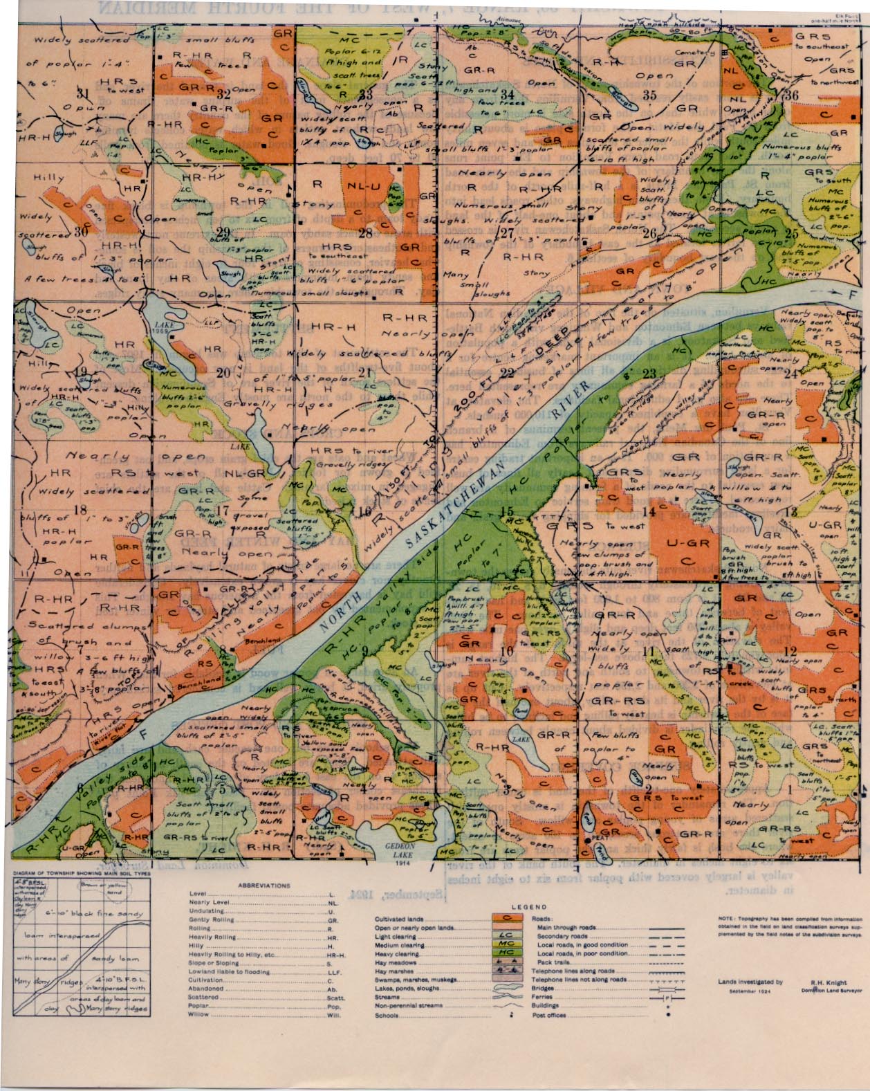
The portion of the township south of North Saskatchewan river is more easily reached from Vermilion than from any other point, while that on the north side is more accessible from St. Paul des Metis. The former place is about thirty miles south while the latter is ten miles west and seven miles north. The main road from Vermilion to Elk point runs along the east boundary of the township and the main road from St. Paul des Metis is a half-mile north of the north boundary. From these main highways, other roads lead into the township at many points and about one-half of the land is easily accessible. The North Saskatchewan river is crossed by two ferries located at the east boundary of the township and on the east boundary of section 6. ,
TOWN AND VILLAGE
Vermilion, situated on the line of the Canadian National railways between Edmonton and Winnipeg via North Battleford and Saskatoon, is a divisional point with a population of about 1,200. It is an important marketing centre for a large surrounding district and all lines of business, essential to the needs of a farming community are represented here. There are also good educational facilities. The elevators at Vermilion have a combined capacity of 110,000 bushels.
St. Paul des Metis, the present terminus of a branch line of the Canadian National railways from Edmonton, has a population of about 900. It is an important trading centre for a large surrounding district and nearly all lines of business essential to the needs of a farming community are well represented. There is a good train service to Edmonton and excellent facilities are provided for shipping stock, grain and dairy products.
SURFACE
North Saskatchewan river cuts diagonally across the township flowing northeasterly through sections 6, 8, 9, 16, 15, 22 , 23 and 25. It is from 800 to 1,000 feet wide and has a current of between three and four miles per hour. The river valley is about 250 feet deep and slightly over one mile wide. The elevation of the river at the middle of the range is approximately 1,725 feet above sea-level. The highest summits within the township to south and north of the river are at elevations of 2,200 and 2,150 feet respectively. Cut up as it is by the river and its deep valley, about one-half the sur- face of the township is heavily rolling and inclined to be hilly, while the remainder is divided about evenly between rolling and gently rolling.
SURFACE COVERING
Approximately one-twelfth of the land is under cultivation. The remainder of the township is mostly open with scattered areas of young poplar and willow. South of the river there are numerous areas, up to 100 acres in extent, where the bush is fairly thick and the poplar trees are from six to eight inches in diameter. The south bank of the river valley is largely covered with poplar from six to eight inches in diameter.
DRAINAGE AND WATER
The general slope of the land is toward the river, and as a consequence most of the surplus water drains off. Because of the rolling nature of the country there are many low lands without outlets in which water collects forming ponds and hay sloughs. Good water is obtained from wells 30 to 70 feet deep.
SOIL
The predominating soil in the township is black fine sandy loam to a depth of from six to ten inches, interspersed with areas of black sandy loam. In the extreme northwesterly and southeasterly corners of the township the soil is some-what heavier, consisting of from four to eight inches of black fine sandy loam interspersed with areas of clay loam and clay. Throughout the township, there are many stony ridges.
SETTLEMENT
The settlement of this township was begun in 1907 and about five-twelfths of the land is now occupied. Most of the settlers south of the river are of Scandinavian descent while those to the north are mostly English-speaking.
CROPS AND STOCK
Wheat and oats are the chief grain crops, and oat green- feed is grown for fodder. Nearly all of the settlers are engaged in mixed farming. Cattle and hogs are the chief kinds of stock raised.
HAY AND WINTER FEED
There are no large tracts of natural hay lands and neither timothy nor clover hay is grown extensively. Considerable wild hay is harvested from the numerous hay sloughs. This is supplemented by oat greenfeed and straw for winter feed For stock.
FUEL
An abundance of poplar wood is available for fuel. When properly dried, it burns well and is considered satisfactory.
SCHOOLS AND POST OFFICES
The schools have but one teacher each and are fairly well attended. They are located on the south boundary of section 4, on the east boundary of section 1, and near the northeast comer of section 29. Peat and Elk Point post offices provided adequate postal facilities.
(Sgd.) R. H. KNIGHT,
Dominion Land Surveyor.
September, 1924. 1


