REPORT ON TOWNSHIP 52, RANGE 3, WEST OF THE FOURTH MERIDIAN
ACCESSIBILITY AND ROADS
This township is reached from either Kitscoty or Islay, two points on the line of the Canadian National Railways between Winnipeg and Edmonton via Saskatoon and North Battleford. From Kitscoty, which is eight miles to the south, there is a main road running north through the township one mile from its east boundary. A main road from Islay, which is four miles south and four miles west, runs north, a mile west of this township. Local roads branching from these main roads make nearly all lands easily accessible. The Canadian Pacific Railway has located a branch line from Edmonton to Lloydminster passing through the northeast corner of this township. Construction was commenced in 1924.
VILLAGE
The village of Kitscoty has a population of about 200. All lines of business essential to the needs of a farming community are represented here. The shipping facilities are good and include five elevators with a total capacity of 285,000 bushels of grain. There is a daily passenger and mail service both east and west.
SURFACE
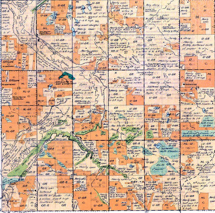
Vermilion river cuts through the westerly part of this township, flowing northerly through sections 7, 17, 16, 21, 29 and 31. It is from 60 to 80 feet wide, and under normal conditions flows sluggishly. The valley is approximately 100 feet deep from the middle of section 17 north, while from this point south it is 200 feet deep. The width of the valley is slightly over one-half mile. The general elevation of the greater part of the township is slightly under 2,000 feet above sea-level, while the highest summit, which is in section 5, has an elevation of slightly over 2,150 feet. The
SURFACE. COVERING
Approximately one-third of the land is under cultivation. The remainder is prairie with scattered small bluffs of young poplar and willows, surface of the land back from the river valley is good, being classified as nearly level, undulating, slightly sloping and gently rolling.
DRAINAGE AND WATER
The township is well drained by Vermilion river and its many tributary watercourses. The river is an important source of water for stock. Good water is obtained from wells, most of which are from 40 to 80 feet deep.
SOIL
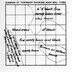
Sections 11 and 12 and parts of sections 1, 2, and 10 have a soil which is mostly black fine sand or 3:ellow sand. Sections 25, 26, 27, 34, 35, 36, 6, 7 and 18 have a soil mostly of black fine sandy loam from 6 to 8 inches deep over clay loam or clay subsoil. The soil of the remainder of the township consists of mixed areas of black fine sandy loam and black sandy loam from 6 to 12 inches deep. Throughout the township there are numerous small stony or gravelly ridges.
SETTLEMENT
The settlement of this township was begun about 1903, just prior to the construction of the railway through the district to the south.
At present, about 70 per cent of the land is occupied, a large amount of which is used as private pasture. The settlers are all English-speaking and they are mostly of Canadian or American origin.
CROPS, STOCK AND WINTER FEED
Wheat and oats are the chief grains grown, although barley and rye are grown to a limited extent. In order of acreage sown, wheat comes first and the oat crop second. All vegetables commonly grown in western Canada are raised in this district. The fodder crop consists of oat greenfeed and oat bundles which are supplemented with a limited amount of wild hay, cut from the upland prairie, and with straw for winter feed for stock.
FUEL
limited amount of poplar wood is obtained in the township and some is brought in from the north. Lignite coal is also used by some farmers. It is shipped in from the Edmonton district and costs from $6 to $8 per ton at railway points.
POST OFFICES AND SCHOOLS
The post offices used by the settlers of this locality are Islay, Kitscoty, Bridstow, Marwayne, and Irwinville. Schools are located near the northwest corner of section 35, in the southwest comer of section 11, on the west side of section 19, and near the southwest corner of section 6.
July, 1924.
(Sgd.)
R. H. KNIGHT,
Dominion Land Surveyor


