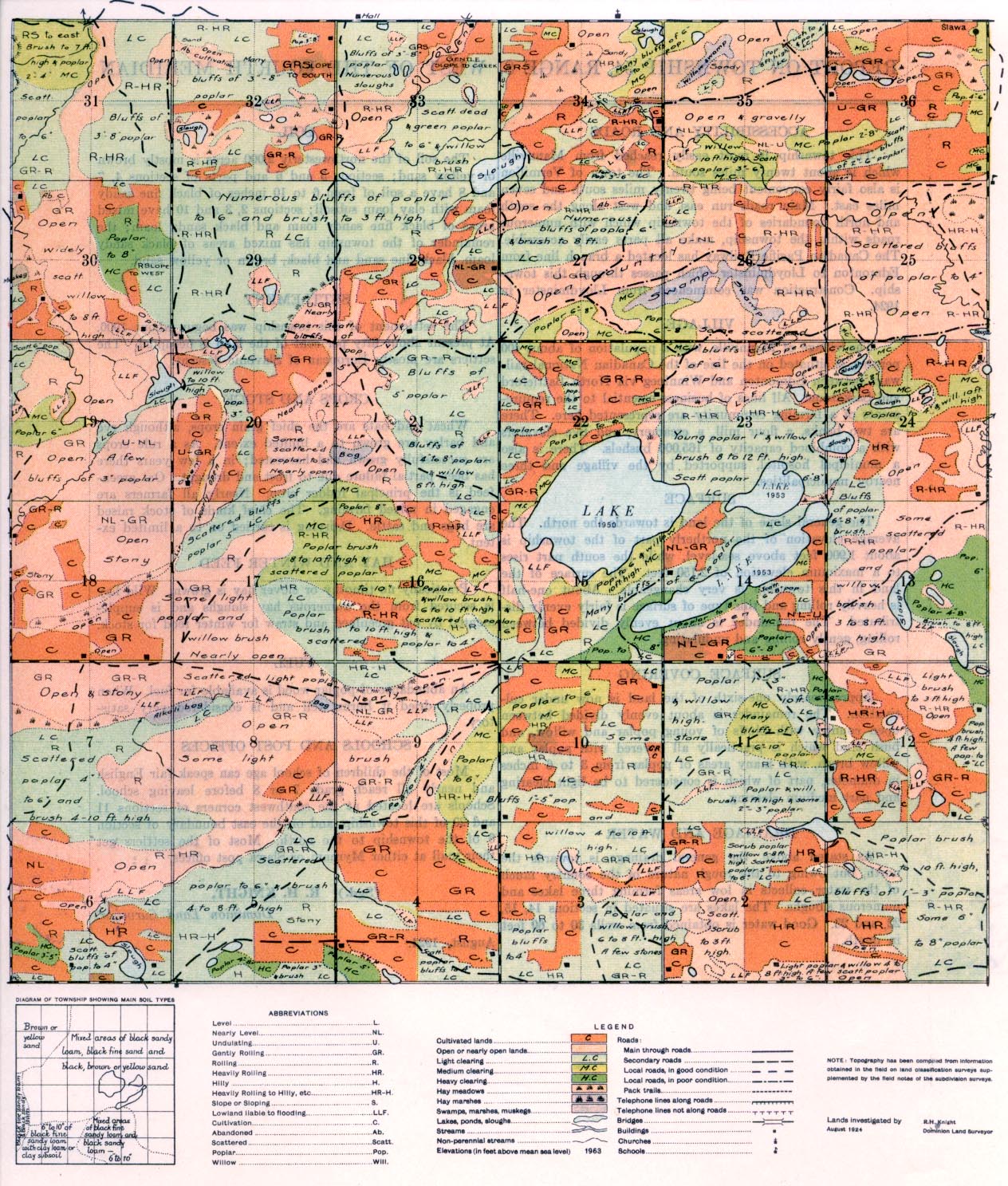
REPORT ON TOWNSHIP 54, RANGE 8 WEST OF THE FOURTH MERIDIAN
ACCESSIBILITY AND ROADS
This township is most easily reached from Mannville which is about twenty miles south. The town of Vermilion, is also fairly convenient being twenty miles south and seven miles east. Main roads run east and west along the south and north boundaries of the township which with numerous roads within the township, make all parts easily accessible. The Canadian Pacific Railway has located a branch line from Edmonton to Lloydminster which passes through this township. Construction was commenced from Lloydminster in 1924.
VILLAGE
The village of Mannville, with a population of about 400 persons, is situated on the line of the Canadian National railways between Edmonton and Winnipeg via North Battleford and Saskatoon. All lines of business essential to the requirements of a farming community are represented here. There are two banks, a flour mill, a creamery, and five elevators with a combined capacity of 165,000 bushels. There is also a municipal hospital, supported by the village and three nearby municipalities.
SURFACE
The general slope of the land is towards the north. The average elevation of the northerly part of the township is about 1,900 feet above sea-level, while the south part rises to a maximum elevation of 2,150 feet. The surface of the land in this township is very changeable. About one-half is heavily rolling and this type of surface is fairly evenly distributed. The remainder is about evenly divided between rolling, gently rolling and undulating.
SURFACE COVERING
Approximately one-sixth of the land is now under cultivation. The remainder is about evenly divided between open country with bluffs
of young poplar and willow, and bush land which is practically all covered with poplar and willow brush, with many areas of poplar from 3 to 6 inches in diameter, part of which is considered to be light clearing and part medium clearing.
DRAINAGE AND WATER
As stated above, the general drainage is towards the north, but owing to the rough nature of the country much of the water collects in low areas forming three lakes and numerous sloughs. The lakes are situated in sections 14, 15, 22, and 23. Good water is obtained from wells 30 to 60 feet in depth.
SOIL
The soil of the northwesterly 2,000 acres is mostly brown or yellow sand; sections 5 and 6 and parts of sections 4, 7 and 8 have a soil of from 6 to 10 inches of black fine sandy loam with clay loam subsoil; sections 2, 3 and 10 have mixed areas of black fine sandy loam and black sandy loam; the remainder of the township has mixed areas of black sandy loam, black fine sand and black, brown or yellow sand.
SETTLEMENT
The settlement of this township was begun about 1906. At present about fifty per cent of the land is occupied. The settlers are mostly European of Slavonic descent.
CROPS AND STOCK
Wheat and oats are the chief grain crops, although rye and barley are grown to a limited extent. As a rule crops are successfully grown and harvested; in a few years there has been partial failure due to frost and drought. Oat greenfeed is the principal fodder crop. Nearly all farmers are engaged in mixed farming. The chief kinds of stock raised are hogs and cattle. Dairying is carried on to a limited extent.
HAY AND WINTER FEED
Practically no timothy or clover hay is grown. Wild hay is secured from the numerous hay sloughs and is supplemented by oat greenfeed and straw for winter feed for stock.
FUEL
An abundance of poplar wood is available for fuel. When properly dried it bums well and is considered very satisfactory.
SCHOOLS AND POST OFFICES
Most of the children of school age can speak fair English and nearly all reach grade 7 or 8 before leaving school. Schools are located at the southwest comers of sections 11 and 29 of this township, and on the east boundary of section 6 of the township to the north. Most of the settlers get their mail at either Mynarn or Slawa post offices.
(Sgd.) R. H. KNIGHT,
Dominion Land Surveyor.
August, 1924.


